

Old Colwyn and Llanddulas
An easy inland walk going through Fairy Glen local...
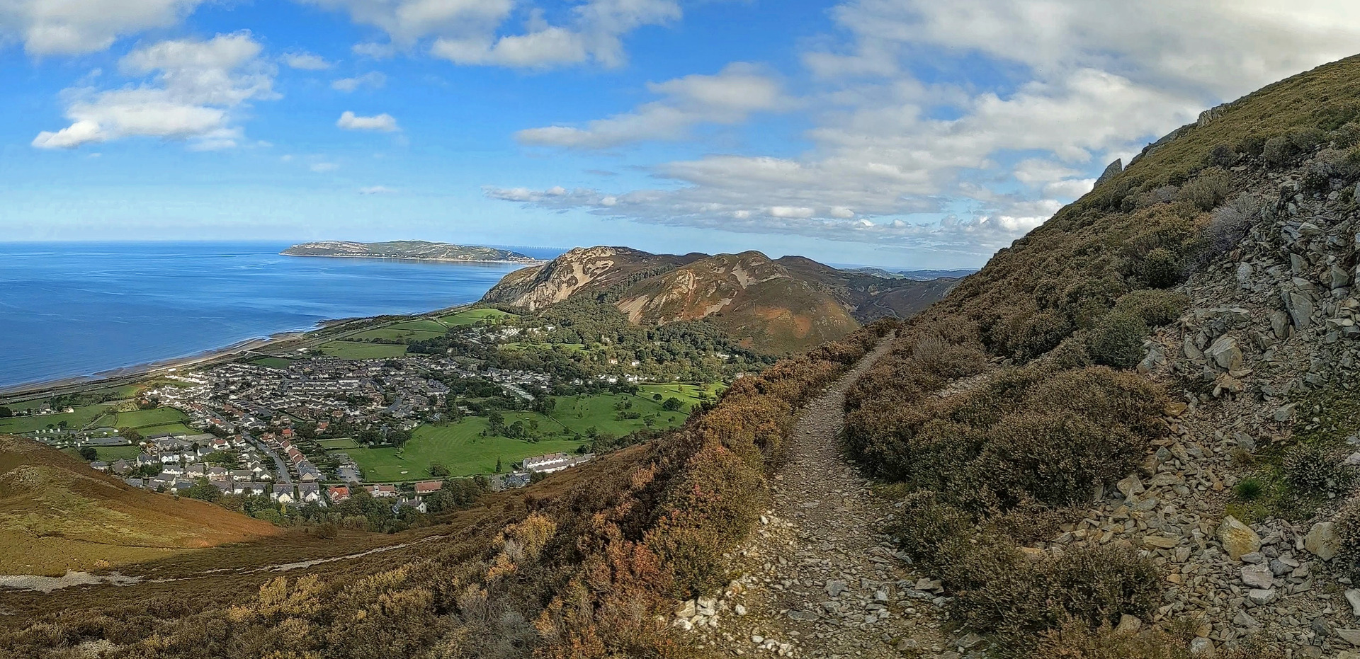
Explore an upland stretch of the Wales Coast Path crossing the foothills of the Carneddau range
Explore an upland stretch of the Wales Coast Path from Llanfairfechan to Dwygyfylchi, crossing the foothills of the Carneddau range. A low-level stretch of the Wales Coast Path runs from Dwygyfylchi, past Penmaenmawr and back to Llanfairfechan, using a stretch of Thomas Telford’s old road around Pen y Clip.
Distance: 11.1 miles or 17.8 kilometres
Start location: Llanfairfechan, at the junction of Penmaenmawr Road, Station Road and Village Road.
Start Grid Ref: SH 68105 74823
Start What 3 Words: melons.passing.ironclad
Parking
Parking available at Llanfairfechan alongside Penmaenmawr Road, at the junction of Station Road and Park Crescent or along the promenade.
Bus
Daily bus services to Llanfairfechan from Bangor, Penmaenmawr, Conwy and Llandudno.
Train
Daily North Wales Coast train services link Llanfairfechan with coastal stations between Chester and Holyhead. Please note that Llanfairfechan is a request stop.
The circular route is marked in dark pink in the map image below. The purple flags show the start and finish point. View the route online and download GPX link Llanfairfechan Dwygyfylchi

1. If starting from Llanfairfechan Railway Station, follow Station Road up to the village centre and note that this riverside road-walk has to be repeated at the end of the day, adding an extra 1.5 kilometre or 1 mile overall.
2. Start in the centre of Llanfairfechan at the junction of Penmaenmawr Road, Station Road and Village Road. A signpost beside traffic lights indicates the local Llanfairfechan Walks, as well as blue signs for the main Wales Coast Path and a red sign for an upland alternative for the Wales Coast Path. The red sign points up Village Road, which is also signposted for the Community Centre. Follow the road and take the second turning on the left, which is Park Road. This road passes old stone buildings, then modern houses.
3. Reach a Wales Coast Path signpost and walk through an iron gate to follow the access track up to Penmaen Park. The rugged mountain of Penmaen Mawr rises ahead, while coastal views include Anglesey and Puffin Island. Catch a glimpse of the house of Wern Isaf, built by the architect Herbert North according to the principles of the Arts and Crafts Movement. Go through a gate and follow a narrow tarmac road onwards.
4 The road runs down past a number of fine properties, then suddenly drops steeply. Don’t turn right as marked for ‘Drws-y-Coed only’, but take the next signposted turning on the right, following a narrow path between houses. Cross a narrow road, then almost immediately turn right up a path that goes behind a house. Go through a kissing gate and follow a woodland path at Tyddyn Drycin. This leads up to a wooden marker post where a sharp right turn is made, to continue climbing further up the wooded slope. Avoid paths leading left and right, simply staying on the most obvious path climbing straight ahead. After the path bends left, turn right as indicated by a marker post and go through a kissing gate to leave Tyddyn Drycin.
5. The path continues climbing, first flanked by fences, then by drystone walls, with glimpses of the coast and Anglesey. Go up a few steps, through a small gate, and a follow a path behind the white-painted Henar Farm. Go through another small gate and continue straight ahead uphill as signposted for the Wales Coast Path. Keep to the right, up a flight of wooden steps, to go through a kissing gate into a field. Rise across a grassy slope, keeping below the line of a tumbled drystone wall, until a marker post points left. Climb steeply through the field and enjoy views from the mountain above to Llanfairfechan below, looking across the sea to Anglesey and Puffin Island.
6. Keep to the left of a farmhouse and pass between its outbuildings as marked to find a four-way signpost. Turn left, still climbing, to follow a path flanked by drystone walls. Go through a kissing gate and climb a narrow path, keeping right of a solitary oak tree as marked. The path appears to be climbing towards a rock face on Penmaen Mawr, but it suddenly swings right, climbing a grassy path between dense gorse bushes. Enjoy fine views back to Llanfairfechan, with Anglesey beyond, while the rounded Carneddau mountains rise inland.
7. The path passes through a gap in a drystone wall, then keep straight ahead as marked, rising gently. Go through a kissing gate beside a small stand of pine trees. The grassy path rises with a drystone wall to the right and masses of gorse scrub to the left. Reach another small stand of pine trees, where there is a signpost. Go through a gap in the drystone wall to join a gravel track, turning left to follow it further uphill. The track bends left later, but turn right instead as marked through a kissing gate.
8. There is no obvious path at first, but follow a drystone wall across the slope and a path gradually develops. Pass beneath a power line and keep following the wall and a stony path to reach a drystone sheepfold. A rutted, grassy track rises to the left, passing easily through dense gorse scrub on a hillside. The track appears to split, but soon re-joins, eventually reaching a marker post. The track swings left at this point, but keep straight ahead instead along a lesser grassy track, still flanked by gorse scrub. When another marker post is reached, note a hollowed-out mound to the right, which is an ancient burial cairn.
9. Walk downhill a little to reach another marker post and turn left along another grassy track, crossing a gap close to the hill of Moelfre. The Wales Coast Path is marked to the left of the track, along a rather vague moorland path. However, this path quickly becomes more obvious once it starts following a drystone wall onwards. There are fine views through a gap in the hills of Great Orme and Little Orme. Pass a stout distance marker, followed by a marker post. The track climbs, with Puffin Island and Anglesey coming into view. A marker post is reached on a gap around 380m, where a decision needs to be made.
10. This area boasts a number of ancient monuments, and the marker post bears a QR code referring to ‘prehistoric stone circles’. The largest stone circle nearby is known as the Druid’s Circle and is over 5,000 years old. To find it, you need to make a detour by turning sharp right to follow a path further uphill for 250m, then return afterwards. Looking around the bleak moorlands surrounding the Druid’s Circle, a smaller circle can be spotted further away, and there may be Carneddau ponies grazing nearby.
11. To continue, follow the Wales Coast Path gently downhill, and the track suddenly bends right. Go through a kissing gate and follow the track as it turns left, passing a line of trees past the remote house of Bryn Derwydd. Go through a gate and follow the track onwards. Later, pass a signpost and a map board that illustrates the relationship between this upland stage of the Wales Coast Path and its lowland counterpart. The track passes through a gap between two heather-covered hills and joins another farm access track.
12. Continue downhill, soon gaining a view of Penmaenmawr with Anglesey and Puffin Island beyond. It is possible to walk all the way down the farm road to short-cut to Penmaenmawr, but that would miss one of the most remarkable paths in the area. Turn right to pass between stone gateway pillars and follow a level, grassy path across a slope of bracken and gorse on Foel Lûs. Continue across a steep slope of heather and scree, passing memorials fixed to a rock face, followed by a small cave. The path overlooks the land enclosed by the headlands of Pen y Clip and Penmaen-bach, where traffic roars along the busy A55 road. The path becomes narrower, but essentially remains level on the steep slope.
13. When a signposted path junction is reached beside a telegraph pole, turn sharp left to walk down a narrow path through bracken and heather. Soon, there are trees dotted on the slope, and it is best to follow the zigzag line of the path as marked, rather than short-cut straight downhill. The path runs through woodland behind houses, passing through a kissing gate before finally landing on the Old Conwy Road above Dwygyfylchi. (Turning right along the Old Conwy Road leads to the Fairy Glen pub at Capelulo and the inland variant of the Wales Coast Path continues onwards to Conwy.) Just across the road is Treforris Road, which leads down past Ysgol Capelulo, though a crossroads and past shops to reach the village centre.
14. Turn right along Groesffordd and walk towards bus shelters, where regular buses run to Conwy, Llandudno, Penmaenmawr, Llanfairfechan and Bangor. However, before reaching the shelters, turn right as signposted ‘beach over footbridge’ to follow a tarmac path that runs behind houses, turning left and right to pass a community allotment. There is access to the Shell Orme View filling station for snacks, otherwise cross a bridge over the busy A55 road, taking in views from Penmaenmawr to Anglesey and Puffin Island, followed by Great Orme and Conwy Mountain.
15. Don’t go all the way across the footbridge, but come down steps halfway across. Double back under the steps and turn left to pick up and follow a tarmac path shared by walkers and cyclists, running parallel to the A55. This is the main Wales Coast Path and it is followed all the way back to Llanfairfechan. Keep a lookout for cyclists and keep to one side, preferably the right. At first the path runs between the A55 road and the railway line, but after passing a roundabout the path crosses over a railway tunnel mouth and drops from the main road to the coast.
16. The coastline is rock-shielded at first, giving way to a pebble beach once the promenade is reached at Penmaenmawr. When kiosks are reached, a detour could be made beneath the road and railway, allowing the railway station to be reached. The large village of Penmaenmawr is a little further inland, which was formerly a fashionable Victorian resort. The original promenade was largely destroyed when the A55 was constructed and the modern version dates from 1988.
17. After the end of the promenade there is a road supported on concrete pillars. Pass beneath the road, then immediately turn right up a flight of steps to get onto the road. Cross over it and turn left to follow it, quickly leaving it to pass through a small car park. A tarmac coastal path and cycleway continues, but soon reaches a junction. Keep left and climb uphill, crossing a bridge over a railway before using a zigzag ramp beneath the main road. Climb 31 concrete steps to reach the old main road at a few houses. Turn right as if heading for the main A55 road and a tunnel mouth, but turn left beforehand as signposted for the cycleway to Llanfairfechan and Bangor.
18. Note the huge bolts holding the mountainside in place at Pen y Clip. Cross a footbridge over the westbound carriageway, overlooking the tunnel mouth, then follow the fenced cycleway as it runs parallel to eastbound carriageway. The way ahead looks like a narrow road, clinging to a steep, rocky slope, and that is exactly what it once was - the original main road constructed by Thomas Telford in 1826. Before that, a more rudimentary road had been constructed by John Sylvester in 1772, and before that the way round the headland was a very dangerous path. A railway tunnel was cut through the Pen y Clip headland in 1848. A new road was opened in 1935, carrying traffic both ways and featuring a stone-built viaduct and two short tunnels. This is now solely for westbound traffic, as a longer road tunnel was opened in 1993 to carry eastbound traffic. In 2009 Telford’s old road was linked back into the road network for use by walkers and cyclists, and became part of the Wales Coast Path in 2012.
19. After passing high above the westbound carriageway, the path runs onto an elevated foobridge between both carriageways of the A55, then crosses the eastbound carriageway. A road is joined and followed beside the A55 for a short way. Turn right down a road called Mona Terrace, passing a terrace of houses then passing a barrier. Continue straight down a road called Pendalar, which has a short tarmac path alongside which should be followed. Continue straight ahead along Penmaenmawr Road, passing houses on the outskirts of Llanfairfechan. Eventually reach a junction and turn left to continue along Penmaenmawr Road, all the way back to the centre of Llanfairfechan. There are several bus stops along the road with regular services to Bangor, Penmaenmawr, Conwy and Llandudno.


